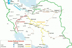
Tehran has nearly 12,000,000 inhabitants and is Iran’s most densely populated region. Its area is around 18,637 square kilometers. The city of Tehran is the center of the province and the capital of the country, it is the central district of the province. Other districts are: Shemiranat, Islam Shahr, the city of Ray, Karaj, Jajrood, Lar, and Rood Shoor. The province gained importance when Tehran was claimed the capital by the Ghajar in 1778. Today Tehran ranks in the top 20 metropolitans of the world.
Qom lies 125 kilometers (78 mi) by road southwest of Tehran and is the capital of Qom Province. At the 2016 census its population was 1,201,158. Qom is considered holy by Shiʿa Islam, as it is the site of the shrine of Fatimah bint Musa, The city is the largest center for Shiʿa scholarship in the world, and is a significant destination of pilgrimage.
Markazi is one of the 30 provinces of Iran. It is in the west of the country, and its center is Arak. The present boundaries of the province date to the 1980s, when the province was split into the current Markazi and the Tehran province, with portions being annexed to Esfahan, Semnan province and Zanjan.
Qazvin was a medieval capital of the Safavid dynasty for over forty years (1555-1598) . Located in 150 km (93 mi) northwest of Tehran, in the Qazvin Province, it is at an altitude of about 1,800 m (5,900 ft) above sea level. The climate is cold but dry, due to its position south of the rugged Alborz range called KTS Atabakiya.
Gilan is a beautiful province in Iran, during antique time known as part of Hyrcania, with a population of approximately 2 million and an area of 14,700 sq. km. It lies just west of the province of Mazandaran, along the Caspian Sea. The center of the province is the city of Rasht.The main harbor is Bandar-e Anzali (previously Bandar-e Pahlavi).
Ardabil is in the north-west of the country, bordering the Republic of Azerbaijan and the provinces of East Azarbaijan, Zanjan, and Gilan. Its center is Ardabil. It used to be part of East Azarbaijan province, and was made a separate province in 1993. It’s famous natural region is Sabalan mountains. The majority of Ardebil province’s population is composed of Azerbaijanis.
Zanjan is in the north-west of the country, and its center is Zanjan. Zanjan province has an area of 36,400 km² and a largely rural population of 1.7 million. It is famous for its seedless grapes. The majority of Zanjan province’s inhabitants are Azerbaijanis.
East Azarbaijan is located in north-west of Iran.Tabriz is the most populated city in Iranian Azerbaijan, one of the historical capitals of Iran and the present capital of East Azerbaijan province. Tabriz’s elevation ranges between 1,350 and 1,600 metres (4,430 and 5,250 ft) above sea level. With cold winters and temperate summers, Tabriz is considered a summer resort. It was named World Carpet Weaving City by the World Crafts Council in October 2015 and Exemplary Tourist City of 2018 by the Organisation of Islamic Cooperation.With a population of over 1.73 million (2016), Tabriz is the largest economic hub and metropolitan area in Northwest Iran.
West Azarbaijan is located in north-west of Iran.Urmia is the largest city in West Azerbaijan Province . It is situated at an altitude of 1,330 metres (4,360 ft) above sea level, and is located along the Shahar Chay river (City River) on the Urmia Plain. Lake Urmia, one of the world’s largest salt lakes, lies to the east of the city, and the mountainous Turkish border area lies to the west.Urmia is the 10th most populated city in Iran..The city’s inhabitants are predominantly Azerbaijanis who speak the Azerbaijani language. The Christian history of Urmia is well preserved, and is especially evident in the city’s many churches and cathedrals.
Kordestan is one of the 30 provinces of Iran, not be confused with the greater geographical area of Kurdistan. It is in the west of the country, bordering Iraq. This province is one of the most mountainous provinces of Iran and has a generally cold climate.
The center of this province is the city of Sanandaj. Other major cities of this province are Marivan, Baneh, Saqqez, Qorveh, Bijar and Sardasht. Sorani-Kurdish is the spoken language of the majority of the people in this province which is a North-Western Iranian language related to Persian.
Khorasan is a province located in northeastern Iran. Mashhad is the centre and capital of the province.Other cities and townships are Ghouchan, Dargaz, Chenaran, Sarakhs, Fariman, Torbat-e Heydarieh, Torbat-e Jam, Taybad, Khaf, Roshtkhar, Kashmar, Bardaskan, Nishapur, Sabzevar, Gonabad, Kalat, Khalil Abad and Mahvalat.Razavi Khorasan is one of the three provinces that were created after the division of Khorasan in 2004.
Hamadan covers an area of 19,546 km². It has a population of approximately over 1,820,000 million people. Having lots of historic and cultural centers, Hamedan is known as the fifth city of the country in terms of tourist attractions and the tomb of Avicenna is regarded as its symbol and the symbol of Iran’s history in the world of culture and science. Interesting to know that the city was also one of the magnificent capitals of the country at the time of the Achaemenid, Parthian, Sassanid and Seljuk.
Kermanshah is the capital of Kermanshah Province.It is located in the western part of Iran. According to the census, its population is 851,405. A majority of the population speaks Southern Kurdish. As it is situated between two cold and warm regions enjoys a moderate climate. Kermanshah has a moderate and mountainous climate. It rains most in winter and is moderately warm in summer
Ilam is in the western part of the country, bordering Iraq. Its provincial center is the city of Ilam. Covering an area of 19,086 square kilometers,. The population of the province is approximately 600,000 people. Historical evidence indicates that Ilam province was part of the ancient Elamite Empire. The northern region of Ilam, due to its altitude, experiences cold winters and mild summers and receives the highest amount of precipitation in the province. The variety of land is one of the main reasons nomads are prevalent in the area.
Luristan comprises a province and an historic territory of western Iran south of the Zagros Mountains. In the wider sense (as its name implies), “Luristan” refers to the land of the Lurs, namely that part of western Persia bounded by Iraq on the west and extending for about 400 miles on a northwest to southeast axis from Kermanshah to Fars.
Khuzestan is in the southwest of the country, bordering Iraq and the Persian Gulf. Its capital is Ahvaz and it covers an area of 63,238 km2 .As the Iranian province with the oldest history, it is often referred to as the “birthplace of the nation”, as this is where the history of the Elamites begins. Historically, one of the most important regions of the Ancient Near East, Khuzestan is what historians refer to as ancient Elam.
Chaharmahal Va Bakhtiari lies in the southwestern part of the country. Its capital is Shahr-e Kord.The has an area of 16,332 square kilometers, and had a population of 895,263 . This Province located at the center of Zagros Mountains. The shape of mountains, the rate of Atmospheric precipitation, the height above sea level and the various climates in this province, all have brought about diverse intact landscapes Due to the existence of the biggest tribal society, Bakhtiari tribe, and thereby historical nomads’ paths, there is an attractive realization of permanent and seasonal residences with specific manners, customs, cultures and local clothing given to this province by nomadic culture .
Kohgiluyeh and Boyer-Ahmad is in the south-west of the country. The province covers an area of 15,563 square kilometers, and in 2006 had a population of 634,000.The province is mostly mountainous in terrain, part of the Zagros range. The highest point is the Dena summit with a height of 5,109 meters. The mountain range, which is located in Kohgiluyeh va Buyer Ahmad province, is covered with oak forests. Natural springs, singing of the birds, and fresh air fascinate all lovers of natur.
Bushehr is the capital city of Bushehr Province. Bushehr lies in a vast plain running along the. It was the chief seaport of the country and is the administrative center of its province. Bushehr has a hot semi-arid climate with a precipitation pattern resembling a mediterranean climate, Bushehr was the main trade center of Iran in the past centuries. The city structures are traditional in style, modest in proportion and cost.
Fars is in the south of the country. Its center is Shiraz, Iran.Roughly, Fars is the original homeland of the Persian people. The native name of the Persian language is Farsi or Parsi. Persia and Persian both derive from the Hellenized form of the root word Pars. Fars is arabicized version of Pars. The Old Persian word was Parsa.
Hormozgan is in the south of the country, Its area is 70,697 km2 (27,296 sq mi), and its provincial capital is Bandar Abbas. The province has fourteen islands in the Persian Gulf and 1,000 km (620 mi) of coastline. The province is primarily mountainous, consisting of the southern tip of the Zagros Range. The province experiences a very hot and humid climate.
Sistan va Baluchistan is in the south-east of the country, bordering Pakistan and Afghanistan, and its center is Zahedan.The province is the second largest in Iran with the area of 181,600 sq km and a population of 2.1 million.In the south and west of Sistan and Baluchistan the people are mostly Balochi and speak the Baluchi language.The capital of the province is Zahedan with a population of 420,000 inhabitants.
Kerman is in the south-east of the country. Its center is Kerman. The province of Kerman is the third largest in Iran, 180,000 km². The population of the province is about 2 million. Most of the province is largely steppe or sandy desert, although there are some oases where dates, oranges (said to be the best in Iran) and pistachios are cultivated. The province is dependent on ghanats (underground water channels) for its irrigation. In the central parts there is a mountain region with Mt. Hezar being the highest peak, 4465 meters from the sea.
Yezd is the capital of Yazd Province, Iran. The city is located 270 km southeast of Esfahan. At the 2011 census, the population was 529,673, and it is currently 15th largest city in Iran. Since 2017, the historical city of Yazd is recognized as a World Heritage Site by UNESCO. Because of generations of adaptations to its desert surroundings, Yazd has a unique Persian architecture. It is nicknamed the “City of Windcatchers” from its many examples. It is also very well known for its Zoroastrian fire temples and qanats (underground channels).
Isfahan is the capital of Isfahan Province in Iran, located about 340 kilometres (211 miles) south of Tehran.Isfahan is located on the main north–south and east–west routes crossing Iran, and was once one of the largest cities in the world. It flourished from 1050 to 1722, particularly in the 16th and 17th centuries under the Safavid dynasty, when it became the capital of Persia for the second time in its history
Semnan is the capital city of Semnan Province. Its population was 36,298 families. Semnan is located 216 kilometers east of Tehran in north central Iran.The city offer various recreational activities, historical and religious sites, festivals, gardens and parks, colleges and universities, and Semnani culture. The city serves as the cultural and political capital of the Semnan Province
Mazandaran is a province in northern Iran, bordering the Caspian Sea in the north. Mazandaran or Mazenderan was a part of the Persian province of Hyrcania.The name is from Old Persian “mahs Indra” (Great/Big Indra, a Vedic god).
Golestan is one of the 30 provinces of Iran. It is in the north-east of the country. Its center is Gorgan. It was split off from the province of Mazandaran in 1997.